Trip #7--Lewis & Clark Caverns and Crystal Park
A couple of weeks ago, I found a notebook that I had used a long time ago and on the first page there was a note that said, "Crystal Park, 2011". I took that as a sign. I've been a rockhound since I was eight years old. There is a place in Montana, near Dillon, called Crystal Park. It's a 220 acre deposit of quartz crystals that is held under claim by the Butte Gem and Mineral Society but the Forest Service manages it. For five dollars you can park your car and dig all day long if you like. All these years of being a rockhound and I had never done this trip. High time I did it. I've taken the kids on digs before and they seem to enjoy it. Garrett has told me that he wants to collect rocks as well.
As I was looking at the map I realized that Lewis & Clark Caverns is about an hour and a half away from Crystal Park. We hadn't been to Lewis & Clark Caverns since our daughter Cynthia was a baby. I looked up on their website and found that the price of admission is a mere $10 for adults and $5 for kids under 12. Ten bucks a head is dirt cheap. Garrett is our only discount kid now. We had to do this.
Last Wednesday was the first day of school, so the kids were free on Monday and Tuesday. We planned to drive up to Lewis & Clark Caverns on Monday, drive down to Dillon after the tour and camp in the Grasshopper Creek Campground near Crystal Park. On Tuesday we would dig until we got tired of digging and head home. Pretty good itinerary and with little deviation we stuck to it. Of course we had Chimene's fried chicken. We can't camp out without that.
We headed north towards West Yellowstone, but turned on the Henry's Lake Flats toward Ennis. When we got to Ennis, I took a wrong turn and headed over to Virginia City. Luckily it was only fifteen miles out of the way. We drove up to Boot Hill and talked about the bad guys buried there and headed back to the road and made our way to Lewis & Clark Caverns. Because of the mixed up detour, we got to the caverns at about ten minutes to four and got in on the four o'clock tour.
There is a mile long trail from the visitor's center to the caverns that rises about 300 feet in elevation. It's paved all the way so it's not a bad walk. All along that trail there are interpretive signs and benches. If I had it to do over again, I'd have stopped at the signs a little more because the tourguide was the last person up the trail and we waited at the cavern entrance for at least fifteen minutes before she got there. The views of the valley, from the trail were incredible.
 |
| The entrance trail and the exit trail from the cavern entrance |
 |
| The valley as viewed from the cavern entrance |
 |
| Rhys and Garrett at the cavern entrance |
 |
| The cavern entrance |
There were thirty or so people on the tour. The tourguide was a young girl (high school age) who had been a tourguide there for three years. She was a little annoying. She had done the tour for so long that she had everything memorized and didn't need to think about what she was saying. Her voice was fairly high pitched and had almost no inflection. Plus, the script hadn't changed appreciably since I took the tour in the 70's and 80's. The jokes are just as bad now as they were back then. She took a few minutes at the beginning of the tour to tell us the history of the caverns and outline the rules, then we took the tour.
The caverns were discovered by deer hunters back in the late 1800's. The reason they are named for Lewis & Clark is that the expedition passed nearby. At the time of the naming, almost nothing had been named for Lewis & Clark, now you can't turn around in western Montana without bumping into something named for them or the expedition. The original guy who claimed ownership of the caverns used to take tours through them and would allow guests to break off stalachtites in one room as souvenirs. That went on for about thirty years, from the turn of the century to the great depression. The railroad claimed they owned the land, and the government agreed. Then the railroad gave it to the federal government who used the Civil Conservation Corps to make some improvements to the caverns. Improvements such as concrete steps and handrails instead of the rickety wooden stairs that the original guy had put in. Finally, the federal government turned it over to the Great State of Montana and Lewis & Clark State Park was born.
The caverns are an active drip cave, meaning the host rock is limestone and water dripping through the millenia has hollowed out the caves, dissolved the limestone and redeposited it in a form called calcium carbonate. That's the same thing pearls are made of, by the way. The calcium carbonate is redeposited in wierd, otherworldly forms called stalachtites, stalagmites, columns, flowstone, helictites and soda straws. Flowstone is the most common formation in solution caves and is formed by more "rapidly" flowing water. It's not rapid at all, just more than the others. Stalachtites grow from the ceiling down, while stalgmites grow from the floor up. When a stalachtite and a stalagmite meet it's called a column. Soda straws are tiny hollow stalachtites. Helictites are very rare, and very fragile and don't survive long in tourist caves. They grow in all directions an look as if gravity didn't have anything to do with their formation. There are very few helicities in Lewis & Clark Caverns. I told you I was a geology nut. I've told my geology professor friends that I'm a geology groupie.
 |
| Stalachtites and stalagmites |
 |
| Flowstone on the cavern wall |
 |
| More flowstone |
 |
| Column surrounded by stalagmites |
 |
| Soda straws |
The last room of the caverns is the most active of all the rooms. It was discovered after the original guy died, so it hasn't had to withstand the vandalism. It's also the largest room in the caverns. Very beautiful. We posed for a group photo there. At the end of the tour, the tourguide asked if there were any questions and I asked, "What is Beethoven's birthday?" She was unprepared for a smart alek on the tour and to my credit, I got a bigger laugh with that than she did on any of her stale, tired jokes.
The Civil Conservation Corps blasted an exit tunnel through 500 feet of solid limestone. They blasted from two directions in the days before GPS and laser sights and were only off by a few inches. Pretty good work by those guys with old school surveying tools.
 |
| Formation in the last room |
 |
| Formation in the last room |
 |
| Group shot |
 |
| Exit tunnel |
After the tour, we drove back to Dillon and then another hour to the campsite which was along the Pioneer Mountains Scenic Byway. When we got there, we had the second hitch in our plans. The Grasshopper Creek Campground was closed for remodelling. It was dusk and I was close to being in trouble with Chimene. Luckily, we had a map in the car and she said it looked like there was another campground a little further north. As it turns out, there are many campgrounds along that scenic byway. We stayed at the Price Creek Campground for $8.00. It was a beautiful, private, quiet campground. We pitched our tent, ate a meal, enjoyed the fire for awhile and went to bed. I will stay there again. It was idyllic.
 |
| Price Creek Campground |
 |
| At the campsite |
 |
| The boys around the fire |
After breakfast, we broke camp and headed over to Crystal Park. The Price Creek Campground was actually much closer to Crystal Park than the Grasshopper Creek Campground, so that was a bonus.
Crystal Park is 220 acres of quartz crystal goodness. It has been core drilled up to 180 feet and they were still finding crystals at that depth. Only hand tools are allowed at Crystal Park so this deposit will never run out. It is immense. It has been heavily dug, though so there are a few strategies for finding crystals. The easiest way is to walk the park and look for shiny things on tailings piles. Chimene found alot of crystals that way. Another strategy is to find areas that have not been dug. That's the hardest way because the whole of the mountain has been dug on. It looks like it was carpet bombed. The other strategy is to find a likely looking hole that has been worked and expand it. That's probably the easiest way to get to virgin ground. That's the way I chose to work and I found some stuff. Next time I go, though I will take a pick and some five gallon buckets to better work the diggings. It was a fun day. We stopped digging at about three o'clock and headed home. We were home several hours before dark.
 |
| The diggings |
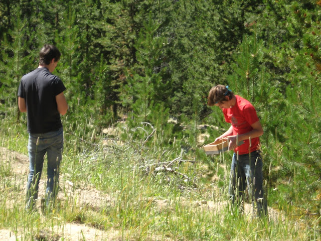 |
| Tyler and Haydn screening for crystals |
 |
| Tyler and Haydn watching the rest of us work |
Gasoline...$100
Lewis & Clark Caverns....$55
Food....$50
Campsite....$8
Parking at Crystal Park....$5
Beautiful Memories....Priceless
.jpg)
.jpg)
.jpg)
.jpg)
.jpg)
.jpg)
.jpg)
.jpg)
.jpg)
.jpg)
.jpg)
.jpg)
.jpg)
.jpg)
.jpg)
.jpg)
.jpg)
.jpg)
.jpg)
.jpg)
.jpg)
.jpg)
.jpg)
.jpg)
.jpg)
.jpg)
.jpg)
.jpg)
.jpg)
.jpg)
.jpg)
.jpg)
.jpg)
.jpg)
.jpg)
.jpg)
.jpg)


