Tuesday, August 30, 2011

How I Spent My Summer--Travelogue: Part VI

Trip #6--R Mountain
Out west of Rexburg, Idaho there is a pair of volcanoes that dominate the skyline.  They are called the "Menan Buttes".  The north butte is the tallest and most of it sits on BLM land.  The south butte is privately owned and a family farms in the crater.  The north butte is referred to as "R Mountain" because of a big white R that is painted on it.  Here in the west, it used to be traditional to paint a big letter on the side of a mountain to indicate something about the area.  The R was either for Rexburg or Ricks College, I was never sure which.  I believe it was for Ricks College because students from there are the ones who always painted the R.  When I was a kid, every year at Ricks College homecoming, students would hike up to the R, cover it with kerosene soaked burlap bags and light it at nightfall.  It would burn for an hour or so and was always a cool thing.  Since Ricks College changed to BYU-Idaho the R has fallen into disrepair and is no longer being maintained.


The north butte, or R Mountain.  The R is barely visible now
These two volcanoes are unique and are studied by vulcanologists from all over the world.  First, they are among the largest tuff cones in the world, and second they erupted through the Snake River and the river gravels.  These are the only tuff cones to do so in North America, so combining that with their size, these are very special cones.  A xenolith is a rock with a different origin than the volcanic material embedded in the tuff.  These volcanoes have xenoliths that are both lava rocks from previous flows and river rocks from the river gravel. 

When I was in the eighth grade, our geology class climbed the north butte for a field trip.  I may have climbed it one other time but I don't remember.  I decided to take my sons up the R this summer and I'm glad I did.  It was a fun hike and we had a great time doing it.  When I climbed it before, I went up the east face trail.  That trail has been closed and now there are two remaining trails on the south side and the west side.  We chose to climb the west face.


My sons at the trailhead on the west face of R Mountain
The trail is well maintained and the first two or three hundred yards is sand and gravel.  As the trail rises, it alternates between dirt, sand, and rock.  The landscape is dominated by large sagebrush and juniper trees and the further up the mountain you go, bizarre rocky outcroppings that look like they belong in a sci-fi movie.  The view out over the valley is breathtaking as well.  To the northwest you can see the remnants of multiple lava flowsand evidence of collapsed lava tubes.


Sagebrush and Junipers
Lava flows and collapsed lava tubes
Rocky outcropping
Toward the summit there were many small caves and overhangs.  In one we found evidence of animals using it for shelter, as there were twigs and bark and leaves gathered together in what looked like a den.


Random cave near the summit
The R Mountain is climbed daily and frequently and is well maintained.  The BLM wishes people to stay on the trail up the face because native plants have been trampled and erosion has ensued, so in places they have built rail fences along the trail to keep people from sensitive areas.  At the summit, the climb becomes steeper and they have placed a chain railing there to assist climbers.  Once on the rim, the view is really incredible.  To the East is the city of Rexburg, to the south is the second butte, to the west is the desert and farmland and to the north is the Island Park Caldera.  At any point on the rim, the crater is also visible.  There are a few trails up on the rim.  One trail follows the rim all the way around and another cuts through the crater.  We only had time to do about half the rim trail and then cut through the crater as we had a Boy Scout court of honor to attend that night.  We chose to do the south rim.


The crater from the west rim
Veiw to the west from the rim
The south rim has many strange rock formations and appears very alien and rugged.  Xenoliths are abundant.  There are interpretive signs in several places on the rim that talk about the geology, biology, ecology, and botany of the buttes.  It all makes for an interesting hike.  We wildcatted around the rocks of the south rim for awhile and explored some of the formations before we found the crater trail and headed for home.  We found a basin or depression that appeared to have water in it in the spring and after rainclouds.  We imagined that this would be a place where some of the lizards, birds and other animals that populate the buttes would come to drink.  This was another great day.


Basin
Rock formations on south rim
Strange rock formation
A xenolith
Alien landscape

Monday, August 29, 2011

How I Spent My Summer--Travelogue: Part V

Trip #5--Sentinel Meadows

Chimene and I decided we needed to get away, just the two of us, so we scheduled a day trip into Yellowstone to do a little hiking.  This was one of those days that we wanted to see things you don't normally see in the park.  We opted for a short hike just before Madison Junction called Harlequin Lake.  I hadn't been on this particular hike since I was a teenager, so I thought it was time for us to see it.  Harlequin Lake Trail is a short hike, only about a half mile long to a cute little lake covered in lilypads.  It was nice, but not a trail I would wish to hike again.  It was short and once you are at the lake there is nothing to do because the tree line is right up to the shore.  I wanted to see it after the fires of 1988 came through.  It had been a much sparser forest back then, but after it burned, the new growth is so heavy that it is almost impassable.  It's a trail worth doing once every twenty-five years or so, I guess.


Harlequin Lake
We decided to take the Firehole Loop Road, which is something we almost always do when visiting Yellowstone.  There are several sets of falls along this stretch of the Firehole River.  There is a small falls furthest downstream, then the larger more picturesque falls that everyone stops to photograph, then the swimming area, and finally above the swimming area is another falls that we had never explored before.  We hiked down to the water's edge to view this section of the falls up close.  We were glad we did.  It was quite stunning.


Chimene and I at Firehole Falls
The upper section of the falls
We stopped at our second favorite pinicking area at Fountain Flats Drive, photographed some random elk and paid our respects to Mattie S. Culver.  She was the wife of the innkeeper at Fountain Flats in the 1800's.  She died of consumption in March and the ground was too frozen to bury her so her husband, E. C. Culver froze her body in two whiskey barrels laid end to end and waited for spring to bury her.  To this day, you can wade out in Nez Perce Creek and pick up white "rocks" and find parts of broken plates and bowls.  When the Culvers would break a piece of china at their inn, they would toss it in the creek.  That "trash" is now an historical park relic and is illegal to remove from the park.


A random elk at Nez Perce Creek/Fountain Flats Drive
Mattie's grave
We picked up the trailhead to Sentinel Meadows at the end of Fountain Flats Drive and Ojo Caliente spring.  Ojo Caliente is a very hot pool that boils down into the creek.  In fact it's the hottest water in the park at 211 degrees.  When I was a teenager, we used to come into the park at night and swim in the river just below Ojo Caliente.  It was some of the nicest water in the park and would alternate between very warm water and cool water depending upon where you swam.


The old swimming hole at Ojo Caliente
In the 1870's, the army was garrisoned in these meadows and named them "Sentinel Meadows" for the three large thermal mounds that dominate the valley.  Superintendent Norris, the second superintendent of the park discovered a hot spring that was just the right temperature for a nice leisurely soak.  The soldiers would do their laundry in the spring and bathe in it as well.  Norris built a small log building at or over the spring and called it "Queen's Laundry Spring" and the structure was called the "Soldier's Bathhouse".  I had hiked to Soldier's Bathhouse when I was a teenager but hadn't been back since.  We decided to find the bathhouse but didn't have any luck and ended up having to blaze our own trail back to the car.  After we returned, I looked at a map and researched where we had gone wrong and next time I'm sure we will find the structure.  When I was a kid, we used to go hot-potting all the time, but now it's very illegal and the punishments are prohibitive so it's no longer worth it.  I do miss that though.


The Sentinels
When we were blazing our own trail back to the car, we stumbled upon a random bison.  He was too tired to gore us so we escaped unharmed.  On the way back to the car, Chimene noticed a really cool rock outcrop and decided that we needed to climb it.  On one side there was a cute little geyser, but on top the view was spectacular.  We will definitely do this hike again.


Random bison
Really cool tree roots
Random rocky outcropping
Random thermal feature
The view from the random rocky outcropping

How I Spent My Summer--Travelogue: Part IV

Trip #4--Lava Tubes

My son-in-law, Nick enjoys exploring and caving.  No matter where he goes, he always finds cool stuff to do.  Then he shares it with the rest of us.  When his friend, John came to visit last month, Nick took John and I and my older sons, Tyler and Haydn out in the Idaho desert to go exploring.

The Idaho desert north of our town was created by lava flows on top of lava flows.  In some canyons, there are up to seven separate lava flows visible.  When lava flows, sometimes it flows into a channel and when it does, the sides and the top of the flow cool faster than the middle, so a hard shell is created.  That shell can be thirty or forty feet thick, or more.  Eventually, the molten lava flows out and all that is left is a hollow tube.  Thousands of years later, sometimes a side will collapse and expose the tube.  Sometimes conditions are just right and ice will form in the tube and there will be ice year round.  They call them, Ice Caves.

Sometimes animals used them for their dens, early Americans used them for shelter and there is evidence that some native peoples have used the ice caves for preservation of food.  During the Cold War, part of the defensive strategy of the United States was to use some of these natural caves to shelter local populations in the event of a nuclear strike.  We have one such cave in the desert here.  They were called the Civil Defense Caves and during the Cold War they were stocked with food and water and supplies.  They were supposed to shelter 8000 people.

While we were in the desert, we spelunked three caves.  The first was the ice cave, the second was a lava tube with no ice and the third was the Civil Defense Caves.

Cave #1-The Ice Cave
This cave has Ice year round.  To get back into it there is a slide worn into the ice from so many people climbing in it year after year.  There are a couple of large chambers and areas where the roof has collapsed so the tunnel is narrow.  At the end of the main tube there is a frozen waterfall.  Above the main tube is another tube that also has ice in it.  We spelunked in both of them.


Rock formations such as this indicate the presence of a collapsed lava tube


Nick, Tyler, Haydn and John getting to the Ice Cave
The Ice cave lava tube has several areas where the ceiling caved in.  To get to the cave you have to climb through several of these areas.


The entrance to the Ice Cave
The ice begins within the first fifteen feet underground in the ice cave.  The main tube has a rope embedded in the ice that you can use to aid yourself down into the main chamber.  After that you have to navigate around a huge ice dam to get into the rest of the cave.  This involves laying on your back and kicking off the ceiling to propel yourselve through the tube.


John at the ice slide
To get to the upper chamber you have to do a little rock climbing with toe holds and finger holds.  It isn't too tough, but one false move and it could be catastrophic.  When you get into the tube, however, the ice crystals on the ceiling are very beautiful.


Ice crystals on the ceiling


Haydn, Tyler and me at the end of the upper cave


The view, emerging from the Ice Cave

Cave #2--The Lava Tube
Nick has lava tube radar, so he set out across the desert for a hundred yards or so and found another lava tube.  This one was much more pristine than the Ice Cave.  This lava tube wasn't collapsed as much as the Ice Cave, so it was long and round.  Almost perfectly so.  We were able to cave in this one for about a quarter mile before it became impassible.  It was very cool inside.


Nick at the entrance of the second cave.
Inside the second cave.
Haydn, Nick and Tyler inside the perfectly round tube.
Cave #3--The Civil Defense Caves
The Civil Defense Caves are about fourteen miles outside of Rexburg, Idaho on the desert.  Nowadays they aren't full of supplies or water, but they are a destination for history buffs, geologists and spelunkers.  I had been here once before, when I was a teenager, but I didn't have a flashlight and stayed in the opening, didn't venture any deeper than the existing light would allow.  I also think I was on a field trip and the teacher wouldn't let us go very far into the caves.


Dirt road from here
Entrance to the Civil Defense Cave
Inside, looking out.
Haydn and John inside cave to show scale
The Civil Defense Caves are two ends of a massive lava tube.  The ceiling in most places was forty to fifty feet high.  The only places it wasn't were the areas where the ceiling had collapsed and there was rubble on the floor.  The main cave is 3000 feet long and about twenty yards wide.  This is a large lava tube and it was the government's idea for surviving a nuclear attack.  Gives new meaning to the term, "Bomb them back to the stone age."

How I Spent My Summer--Travelogue: Part III

Trip #3--Union Falls

My son Haydn went on a trip with the Varsity Scouts this summer, called High Adventure.  They camped near the Bechler area of Yellowstone, just outside the park and made day hikes into the park.  Since we have been obsessed with Yellowstone's waterfalls for the last three or four years I thought it would be fun to take the hike with him to Union Falls.

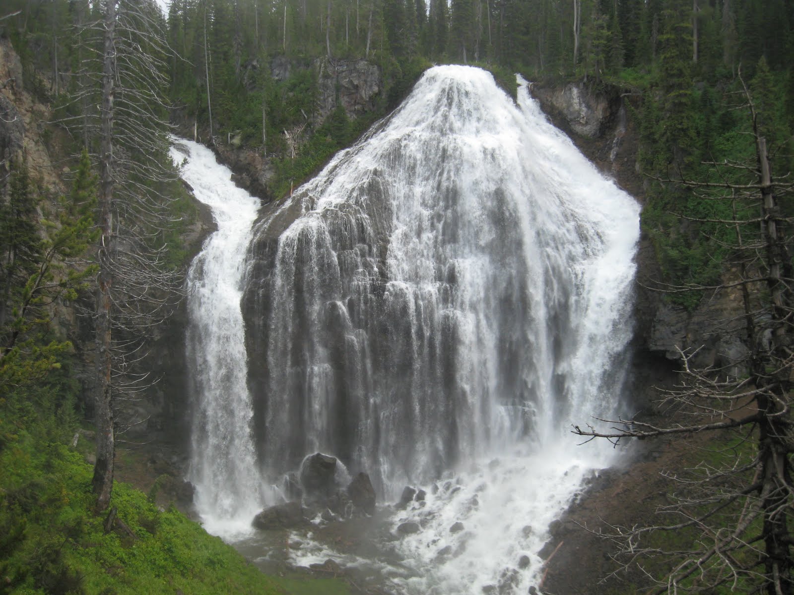
Union Falls is the second highest waterfall in Yellowstone National Park, and is so named because two rivers meet at the falls and their waters mingle on the way down.  It is very spectacular and only a small percentage of park visitors ever see it.  The trail takes hikers deep into the backcountry of Yellowstone and many people camp along the trail.  It is possible to do the hike as a day trip though, but it is a long one.  The hike is 7 miles one way, but at the end there is a side hike of another half mile to a swimming hole that is a must if you make the hike to Union Falls.  With the side hike, it became a sixteen miler.

We drove from Ashton, Idaho along the Grassy Lake Road and parked on the far end of the dam.  Grassy Lake sits just outside of Yellowstone.  The trail we took is called, Mountain Ash Trail.  There is only about a 300 foot elevation shift, but you lose it and gain it several times during the hike.  The trail is through a beautiful forest of white pine, lodgepole pine and douglas fir.  The undergrowth is lush and green.  It was a very pleasant hike.  Most of it was shaded.  We had one major river crossing where we had to get wet, but the rest of them had fallen logs that we could cross.


Haydn at the river crossing
Leaders and a scout crossing a stream
A view from the trail
The last half mile was the toughest because it's all uphill and sandy so it's quite a slog to get there.  After hiking the face of Table Rock, though I wasn't complaining.  Once we got to the falls, though the view was breathtaking.  The vantage point the next photo was taken from was about 150 yards away and still the mist from the falls was everywhere.  That was very refreshing after hiking through the hot sun the last mile or so.


Union Falls
Haydn and I in front of Union Falls
After that, we ate lunch and then made the pilgrimage to the swimming hole.  The neat thing about the swimming hole is there was another waterfall.


At Scout Pool
This was a great day.

How I Spent My Summer--Travelogue: Part II

Trip #2--Table Rock

My son turned 12 in the middle of scout camp this year.  On his twelfth birthday the scouts were scheduled to climb Table Rock.  I decided to climb it with him.

Table Rock is a very popular hike in the Teton Range.  It doesn't require any technical climbing, just hiking.  There are two major trails to the summit of Table Rock, the Huckleberry Trail and the Face Trail.  The Huckleberry Trail is a switchback trail, about 7 miles from the trailhead to the summit and the face trail is about 4 miles without many switchbacks.  The elevation gain on both hikes is 4000 feet.  That makes the Face Trail brutal.

Table Rock is a large sedimentary rock about 10 yards wide by about a hundred yards long.  It's elevation is 11,106 feet above sea level.  Approximately the elevation of base camp on Everest.  From Table Rock you get the best view of the west face of the Grand Teton.  Once you summit and see that mountain, all thoughts of, "was this really worth it?" melt away.

I climbed Table Rock twice when I was a scout and attended Treasure Mountain Boy Scout Camp.  Both times I climbed it, though we took the Huckleberry Trail.  This year, however there was more snow than usual in the Tetons and the spring runoff had washed out four bridges and the streams were impassable on Huckleberry.  In addition, the switchbacks for the last two miles were covered with ice.  The part of the trail that was iced over has sheer cliffs dropping off over 3000 feet.  Huckleberry wasn't an option this year.  We climbed the face.

I was a little concerned for my twelve year old, wondering if he could make this climb.  That was one of the reasons I decided to go.  I also wanted to celebrate his birthday with him on Table Rock.  I thought that would be cool.

We started out on the trail at about 7 AM and it didn't take very long for me to realize that my son did not need my help.  Within the first mile the faster hikers outpaced us and I didn't see any of them again until we reached the summit.  Rhys, my son was in that first group.  Out of 17 people that climbed, my son was the fifth person to summit.  I was the last.

About a mile up the trail, two of the scouts told the scoutmaster that it was too hard and they didn't want to do it.  They tried to convince us to go back down the trail.  He and I had to pep talk those two boys to get them to finish the hike.  We took as long as we needed to and rested alot, but they finally decided that this mountain was not going to beat them.  I was proud of them.  The last mile and a half, they pushed ahead and summitted well ahead of the scoutmaster and me.

The Face Trail is very steep, and there is a sign at the trailhead that says it is not recommended.  I have bad knees from an injuy I sustained in grad school, so the going was a little rougher for me than some of the others.  The scenery was magnificent though.  We set goals for how far we would go before we rested and made it up the mountain that way.  Most of the elevation gain was in the first two and a half miles.  The last mile and a half, the elevation gain was steady but very manageable.  The problem with climbing a mountain, though is that every time you cross a ridge, it seems there's another ridge in front of you that needs to be crested.

Just before the summit, there is a field of fractured boulders that was very interesting to me.  It was all sedimentary rock and fossil bearing.  The neatest fossils were the worm burrows.  I don't know the age of the fossils, but there are worm tracks all through some of the boulders.  Among the other fossils I saw were rain impressions.  Those were very cool as well. 

After the boulder field were large patches of snow and at this point of the climb I knelt down several times for several minutes at a time to ice my knees.  I don't know if I'd have made it up the summit if it hadn't been for the snow.  When I finally got to the summit, Rhys came down to guide me up to the top.  That was very cool.  No one told him to do it, he came down for me.  I appreciated that.  When I got to the summit, all 16 of us sang "Happy Birthday" to my son on Table Rock.  It was a great day.


Rhys and I on Table Rock

How I Spent My Summer--Travelogue: Part I

Because I teach three semesters, my summer doesn't start until the middle of July.  Usually I have a little time during June and July to kick back and enjoy some family time in Yellowstone, but this year I had a very large production of Oedipus going up onstage and I didn't have time to do anything else.  My garden suffered, my leisure time with the family was non-existent.  All I could do was work. 

We made up for lost time in the last several weeks, though and have done a great deal since.  I will break this up over several blog posts.  You can click on the photos to view them larger.

Trip #1--Yellowstone
This was a whole family trip.  Nick and Cynthia and their kids, Ashley, Chimene and I and the boys.  It was the Fourth of July and we decided to spend it in Yellowstone instead of going to Idaho Falls to brave the crowd of 100,000 people or so gathered to watch Frank VanDerSloot blow a million dollars.  After the parade, we headed North to Yellowstone and met up with our good friends, the Airths at Sheepeater Cliffs for a picnic.

Sheepeater Cliffs is my very favorite place to picnic in Yellowstone.  Its an exposed cliff of columnar jointed basalt next to the Gardiner River.  After the picnic, we climbed the cliff.


Climbing Sheepeater Cliffs
After the climb, we hiked for a half mile or so along the bank of the Gardiner River to a beautiful cascading waterfall that isn't marked, I'm not even sure it's named.  This waterfall is mainly seen by fishermen because almost no one else ever takes this trail.  That's a pity because it's magnificent.  Three or four years ago, we went on a trip to Yellowstone and decided, "You know how we drive past things and say, 'one of these days we should stop and see that?' well, today is 'one of those days'."  We hit all the side attractions instead of the big touristy places and rediscovered how exciting Yellowstone can really be.  That was how we discovered this particular waterfall.  We have been back every year ever since.  We have also gone on a pilgrimage to see as many of the park's 300 waterfalls as we can.  We love the hidden Yellowstone.


Cascades on the Gardiner River


Kids, grandkids and friend on the trail
After the hike to the falls, we drove up to Mammoth Hot Springs because our friends had never seen it.  Mammoth Hot Springs is a shadow of it's former glory, unfortunately because of some earthquakes and tremors the plumbing under the feature has changed.  It's still spectacular but not anything like it once was.


One of the better views of Mammoth Hot Springs
After walking the boardwalks, we went to the lodge at Mammoth and had ice cream.  No summer is complete without eating the ice cream in Yellowstone.  It just tastes better than anywhere else. 

We made it home before dark and had our obligatory fireworks display with our friends.  All in all, a great day.

Back on the blog

I took a very long hiatus from blogging, but now I think I'm ready to get back on the horse.  Just to update.